The Search for Napa area land owned by Jacob Anderson Family
This map shows a portion of current southern
CLICK HERE FOR LARGER VERSION OF MAP
.
NOTE 1: In reading this material, it will become apparent that the name of this area is spelled in different ways, namely "Soscol" and "Suscol." Gardner's "Historic Report" points out that "Suscol" is "An error in spelling. 'Soscol', the Spanish spelling of the Indian name, appears in various land grants from 1835." Gardner further states, "Early historical reference is made to the fact that there were many errors in the drafting of the first U.S. Geological Surveys of the early 1850's"1
.
|
This
Norwegian immigrant pioneer family moved west to And it was
in this area and time that the Jacob Anderson family was settling in southern
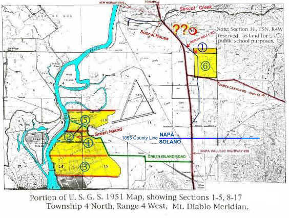
To further complicate understanding early land purchases in this area, the southern boundary of Napa County was moved in these early days. Suscol Creek was the 1840's boundary line between Cyetano Jarez's Rancho Tulocay and Mariano Vallejo's Rancho Suscol. The Senate County committee of the First Legislature meeting in San Jose 1849/50, established Suscol Creek as the boundary between Napa and Solano counties. Senator Mariano Vallejo was Chairman of the committee. In 1855 the legislature moved the county line several miles south of Suscol Creek to an east-west line just south of the current Napa Airport. The Napa-Solano county line was moved further south in the 1860's to about six miles south of Soscol Creek where it exists today (marking the south city limits of the town of American Canyon). It is now believed that the Anderson family first bought land east or south east of the Soscol House which was later determined to be in Section 36 of Township 5 North, Range 4 West (#1 on map & table on separate page). Apparently some early settlers bought Suscol Grant land only later to find that it fell within the 36th section of a township. Such a Section 36 is often called a “School Section” with rights transferred from Federal to State government for public or school uses. This complicated the already complex title questions in this general area, especially Section 36 which was found to lie just east of the early community of Soscol. Litigation over title of land in this area continued well past the time of Jacob’s death and even after the family had left Napa County.3
* Recent
material unearthed (Dec. '03) by Floyd Stone of the Napa County Historical
Society gives conclusive evidence that the Anderson family had "been in
possession and occupation" of land in this Section 36 "since about the
year 1857..." In a continuing process of settling the estate of Jacob
Anderson in 1866, legal title was established for 20 acres in the south part of
the southeast quarter of Sections 36. This is shown by the blue circled #1
in the map above. The red "X" is currently conjectured to be
the location of the Anderson home from 1857 to 1867. This finding does not
explain the location of the other 30 acres of the original 50 purchased from
Frisbie. Those 30 acres could have been farther north in to Section 36 or
to the south and became part of the 160 acres of the northeast quarter of
Section 1 (circled #6 on the above map). The second
record of land purchase for Jacob was the 80 acres obtained from Jacob's son-in-law
David Oaks recorded in the spring of 1861. This was low land to the
south west of the Soscol House bounded by the Little is
known about the “quarter section” or 160 acre square block of land in the
northeast portion of Section 1 (#6 on map & table) other than its
location and that it was deeded by Jacob and Serena to their son Andrew J. in
May of 1862. Today this parcel holds a
prominent and visible location adjacent to two busy area roads, State Highway
12 between highways 29 and 80, and Even less is known about the 320 acres (#7 on attached table) that were transferred from Andrew J. to Jacob on the same date as #6 above. It is possible that this could be the northern portion of “Swamp & Overflowed Lands” surveyed in 1861, Survey No. 98 (#5 on map & table).
Many questions remain about these land transactions and the lives of the Anderson family during these early years. Did this family actually settle in this Soscol area when they first came to California or could they have lived elsewhere first? There has always been unclear connections between this family and the area of Jackson in the gold country's Amador County. Some have suggested that the family might have first been "squatters" in the Soscol area before purchasing property. This apparently was a common practice in this area at that time, but this does not seem to have been the pattern with this family, at least in the past.
The question remains regarding the location of the "Mountain House near Suscol" where Martha Anderson's husband, Augustus Wheeler, died in 1862. Could this have been on the low mountain in Section 36 just east of the Soscol House? Could that have been on land belonging to the Andersons?
And why did this family leave this area with most members moving back to their Iowa farm land? Hopefully, future research might shed some light on these questions.
|
CLICK HERE FOR ADDITIONAL DETAILS ON
THIS LAND SEARCH
.
CLICK
HERE FOR RECENT PHOTOS OF SOME
LANDS IN QUESTION
References
- Gardner, David. "Suscol in Napa County An Historic Report 1835-1977." Feb. 1977.
- Delaplane, Kristin.
“
- “Judge
Wallace’s Opinion,” Napa County
Reporter,
- “S.1 Project Background; [PDF] Summary.” Napa River Salt Marsh Restoration Project, Draft Environmental Impact Report/Environmental Impact Statement, April 2003, p. S-1; as found online at: www.napa-sonoma-marsh.org/documents/ DEIR/text/Summary_DT.pdf
- Rosdail,
J. Hart. The Sloopers; Their Ancestry and Posterity; The Story of the People on the Norwegian Mayflower, The
Sloop, "Restoration.".
- Laurence,
Bee. “Thompson Turned Land Into Showplace,” The
Return
to